Drone Imaging
Our state-of-the-art drone imaging equipment and talented professionals have the ability to capture your facility from the unique aerial point of view. Providing you with this new perspective, we can improve your operations, whether through thermal imaging and analysis, enhanced inspections, or monitoring site progress and development. Our FAA licensed pilot, focused on precision, safety, and accuracy, in conjunction with our team of engineers, delivers a comprehensive analysis of the results and quantifies cost benefits for improvements.
Our flight paths are always pre-planned with a strategic route to ensure we capture an accurate drone imaging scan while complying with federal regulations and safety codes. The Advanced Smart Controller is set to capture thousands of waypoints to optimize maximum efficiency for flight path.
Thermal Imaging

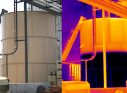
By capturing thousands of thermal UAV images from the air, we are able to apply infrared radiation technology to measure the thermal energy emitted from each component in your facility. Combining this technology with the use of drones, we gain the ability to capture a vast area quickly, as well as examine tall vessels, structures, and hard to reach areas more efficiently.
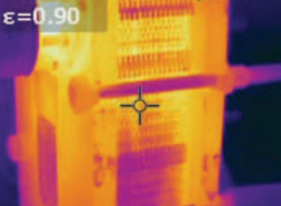
Targeted thermal imaging of smaller areas from the ground level can be accomplished using a handheld device to capture items including Tanks, Motors, Pumps, Valves, and Heat Exchangers. This non-invasive process keeps operations up and running while maintaining a safety-first approach.
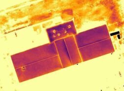
Once we have the thermal drone footage, we can overlay the thermal scan with the RGB scan to create a realistic view of your facility. Viewing RGB and Thermal images side by side enhances the ability to identify problem areas by contrasting temperature differences and finding detailed locations for points of interest.
Thermal Mapping and Analysis
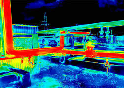
A step beyond multiple still images, thermal mapping compiles images to create a full map of the area. Combining the visual and thermal data allows our team to perform a quantitative analysis of energy lost through unwanted hot spots. Our team incorporates these heat loss findings with the owner’s cost of energy. They can then recommended improvements to yield the highest dollar-per-year savings.
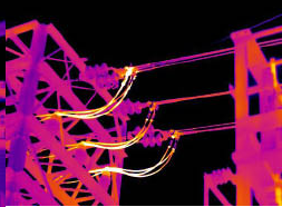
As an added benefit, these scans bring process safety concerns to the surface. They can highlight uninsulated piping or relieving events/relief valve malfunctions shown by hot spots in flare piping. Catching these concerns early protects the environment and supports the safety of your facility and staff.
Applications for Drone Imaging

- Solar Panel Inspections
- Utility and Electrical Inspections
- Equipment Inspections
- Tank Level Inspections
- Heat Exchanger Inspections
- Pump Inspections
- Roof Inspections
- Pipeline Inspections
- Cell Tower Inspections
- Construction Progress
- Stockpile Analysis
- Commercial Land Development